Showing posts with label Waterfalls. Show all posts

11.02.2018

Raging...

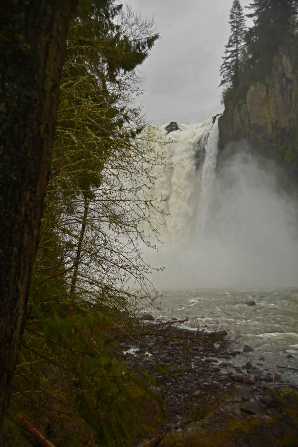
This morning, DW and I headed for the little town of Snoqualmie and breakfast at a tiny diner right in the old part of town. We lingered and watched the rain fall, then drove downriver to see our magnificent waterfall, Snoqualmie Falls. The river is near flood stage thanks to days of rain in the Cascades, and we knew the flow would be about as high as it gets. 

                      Our spectacular 269-foot Snoqualmie Falls

As we walked through the trees toward the edge, we could already see the spray high above the river. Two hundred feet from the railing, we were getting soaked. Raincoats helped, umbrellas were useless (as many were learning the hard way).

Leaning over the railing, the falls was am amazing sight to see. The water over the falls thundered down to the river, then bounced up nearly half the height of the falls. The spray from the falling water blew up and soaked everyone along the edge. 

It isn't always this full, of course. The river has flood controls, and in past years I've even seen it with nothing but a trickle of water. One of these days I'll dig up those photos and post them; seeing the falls with no water is almost as interesting as seeing it at flood stage.

4.18.2018

Snoqualmie...

We escaped the rain this morning, headed north to the Snoqualmie valley for a hike. Tolt-MacDonald Park is on two levels: pastoral green fields below, where the farm used to be, and a repurposed barn that was once part of the dairy farm. But cross the river on a somewhat creepy suspension bridge, you can climb the trails to a forest high on a bluff above the Snoqualmie River. It's a favorite of mountain bikers; once you get up the steep switchbacks to the top, you can ride for miles on singletrack and old logging roads.

We came up to find one of the oldest geocaches in the state, placed in early 2001, then we just explored. At the top of a "shortcut" trail back down the bluff to the river, we found this amazing view across the valley to the fresh snow in the Cascades.


The shortcut didn't turn out to be the fast trail we'd hoped. It was shorter than retracing our steps, but it was a steep, root-laden, slippery, sometimes hair-raising trek back to the park. I was glad to have a walking stick, and glad for roots and branches to hang on to in the worst spots. And most of all, I was glad it hadn't rained recently. It would be a nasty, slick trail when wet.

We had the chance to stop by Snoqualmie Falls this morning, but I decided to wait until after our hike. Which turned out to be a bad call. Just as we drove out of the park, it started to rain. And when we got to the falls it was raining so hard, I didn't want to risk my camera. A few quick shots of the falls in full force, and we ran back to the car. 

4.15.2018

Family time...

A break in the weather. My sister, niece, and great nieces in town. We met for lunch at the Issaquah Brewhouse (where I had perhaps the world's best grilled cheese sandwich), then we headed for Snoqualmie Falls to check out the lower falls park.


We always go to the upper falls viewpoint, but this time we decided to check out the lower viewpoint. We got a bird's-eye view of the power station, the roaring Snoqualmie River, and the new boardwalks.


The girls and Dave solved a geocache together.


The star of the show was the stupendous flow of water over the falls. From the lower viewpoint you don't get to see the whole waterfall, but it was still an amazing sight.


A section of the original water pipe was cut into rings, to walk through.


A brilliant yellow shrub was in full bloom, covered in water droplets that sparkled in the sun.


There's nothing like getting outside and exploring with family.

9.16.2017

Sol Duc Falls...


I first saw a photograph of Sol Duc Falls on Instagram, a couple of summers ago. It seems that photographing waterfalls was the thing to do that summer, and every time I opened up IG, there were more photos of waterfalls. There were so many waterfalls that I drooled over, and vowed to go see for myself. Most were in the Columbia Gorge, but Sol Duc Falls on the Olympic Peninsula really appealed to me.

Last March we spent our anniversary weekend in Port Angeles, and early one morning, we tried to hike to Sol Duc Falls. But we were a week too early, and the road was still closed. So we made sure the road was open for this trip, and this morning we shouldered our day packs and headed up the trail.


It's a short 8/10 mile to the bridge over the river, with a picture perfect view of the three separate cascades that flow over the basalt cliff. The trail was popular, and cameras and tripods were everywhere. But I managed to get a few shots without a lot of people in them.

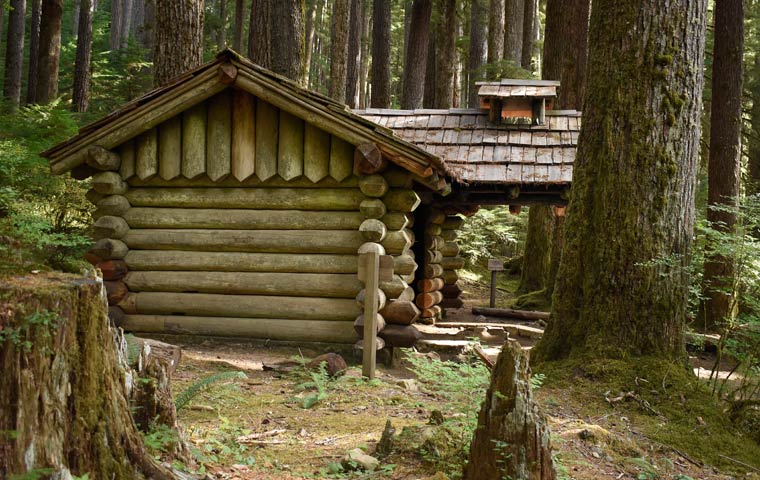
Before we walked back out, we stopped to see the trail shelter that stands on a ledge above the falls, built of logs with an ingenious covered fire ring and chimney just outside the doorway. The shelter is closed for restoration, and the inside has been stripped of bunks and shelving. It's a historic building, and a marker sign explains its history.


I am happy to check this waterfall off my list.

5.21.2017

Umptanum light...

The hike to Umptanum Falls brings you right to the top of the waterfall. There's a shallow pool at the top, and the water foams and spills right over the edge of a basalt cliff.


If you want to see the waterfall straight on, you scramble up a steep rock slope (with the help of a rope) across the top of a slot canyon, and down the other side. It's worth every rocky step.


We arrived at the wrong time of day for good photographs, but that's how it happens some times. But as we hiked back toward the trailhead, I got my reward: perfect light out of the west to shine through a grove of aspen trees.


9.23.2016

Cold rain...

The weather has really taken a turn for the worse, but we're heading back to Mt. Rainier in spite of the weather.

East of Federation Forest, as we headed off to circumnavigate the national park, we looked both ways then hopped the guard rail and down into this forest of ancient trees. The patriarch has fallen, taking a fair number of big trees with it, to lie undisturbed between trail and river. You can climb up on the stump (which would hold my round dining room table and 6 chairs), but even more impressive is standing beside the tree.


Next stop, in even harder (and colder) rain, was the Box Canyon, which is in the park from Stevens Canyon entrance. We always stop here to walk the trail and look down at the Muddy Fork of the Cowlitz River. from this bridge, the surface of the river is about 130 feet below, and the canyon is less than 18 feet wide.


As you walk the loop, the huge rock to the right is scoured with deep glacial scratches. We crossed the bridge and decided to keep on walking the loop, even though that meant scrambling over a couple of downed trees. Thoroughly wet by this time, we ran back to the Pilot.


The last stop was at what is probably my favorite waterfall, Christine Falls. It's another place in the park where we always stop, and rarely do we get to see it without fifty people in the way of my photo. The weather worked to our advantage today. Christine Falls is a two-drop falls and is very pretty, but what makes it a beautiful view is the frame made by the stone bridge that crosses the river. I know the view so well, but I never get tired of it.


Wet, but happy with our day, we headed for Buckley and a burger and beer at The Firehouse. Relaxing in this packed bar and grill was the perfect way to end a long day.

11.05.2015

Misty day...


It's warmed up, but the rain is back with a vengeance. DW is glad he cleaned gutters yesterday! I puttered much of the morning, then snuggled with Murphy (who has taken up residence between us on the sofa), and browsed some of my favorite landscape photography blogs.

We're going to a release party at DeLille Cellars tonight, and took the back roads. On the way we made a stop at Snoqualmie Falls, to see what all this rain has done to the flow of water. It was pretty spectacular,. but the mist blowing in our faces made the falls hard to see. I brought the Nikon, but it was so wet at the overlook, I kept it safely in my bag and used my cell phone instead.

Growing up here, I must have visited the falls hundreds of times, but I never get tired of it. One of these next nice days, before winter really arrives, I'd like to come back and hike to the base of the falls. That's something I've never done.

When we drove home this evening, there was mist in all the low, wet places... just like at the falls. Beautiful, and just a bit spooky.

4.21.2015

Exploring...


It was such fun today, exploring and taking pictures with a long-time friend who loves photography as much as I do.


The lilacs are in bloom, and the native maple trees are full of plump catkins and bright green leaves, and the river is swollen with runoff from nearby snowfields.

Today we explored in the Snoqualmie River Valley. Next time, who knows? But I know it will be just as much fun as today.

4.16.2015

Wandering... Victor Falls

My camera and I headed out on the back roads today, and while following my nose toward Buckley, I stumbled across a brand-new parking area for Victor Falls. I knew about the falls because a very popular mountain biking area bears the name, and had always intended to ride there. But I'd never seen the waterfall before. There is probably a way down to the creek bed for better views (there was mention of a steep root ladder) but I declined... I was satisfied with taking a few photos from the top.

Victor Falls near Bonney Lake
Curtain-type waterfall, 70 feet high

3.14.2015

Places grown wild...

It's our third day on the Hilo coast, and we're walking the path to Akaka Falls. I've decided I much prefer this wetter, greener side of the Big Island. Maybe it's because of where I was born and raised...  probably exactly because of that. It is warmer here, and the rain is warm. So I didn't at all mind going walking in the rain. And the lush green is just like spring at home.


5.07.2013

Shoshone Falls

Day 3 of our road trip through Central Idaho.

We spent the night in Twin Falls, and as we were headed north, noticed the waterfall symbol on the map. Since we had to stop and grab a geocache nearby, and since the waterfall was just a few miles away, we decided to check it out.

For anyone who hasn't been to Twin Falls, or has just driven past on the freeway, you may not have noticed that the Snake River flows immediately north of town. It's the reason the town stopped where it did, actually. The Snake has carved a deep gorge here, spanned by only a few bridges, with a few overlooks where you can walk to the edge and look down.

Shoshone Falls is 212 ft high, which is 45 ft higher than Niagara Falls. And it flows in several cascades over a 1000 ft wide rim. We were lucky to see it in spring when the water was still pretty high, but I'd like to see it when water is flowing over the entire rim.

We stopped at the upper overlook, and debated over spending the 3 bucks to drive down to the lower viewpoint. A guy who'd just jogged up the steep road overheard us, and said the view was so much better from down below, and worth every penny. So we went, and were really glad we did. This is a truly spectacular waterfall.