Showing posts with label Mt. Rainier. Show all posts

2.23.2019

The mountain is missing...


There was no mountain here today, but you can see the foothills crowned with fresh snow in the distance, and the sky was heading toward blue. It's one of my favorite places to see the mountain, high on a ridge overlooking a golf course. And it was early enough that the foreground wasn't cluttered with golfers... just the way I like it.

3.05.2018

In hiding...

It's a common theme so far this month... snow in the foothills, cold in the valley, and no mountain in sight. This morning we got on the road early and headed south for a walk on a rail trail. The sun was coming up strong and light, and the snow in the low foothills was shining. I could post this photograph on a wall and draw in the outline of Mount Rainier. It's there, but you'll have to take my word for it.


This plateau, nestled at the foot of The Mountain, is one of my favorite places (as I've said before). From one side to the other, it's full of green pastures for dairy cows and horses, old farmhouses and barns, and lots of funny bumpy hills that rise straight up from the plateau floor. It's also home to a few favorite restaurants and bars. And it's one of my favorite areas to roam with my camera.

I could live there... if I could just move it to a different county. Maybe a different state.

11.09.2017

A year and a day...


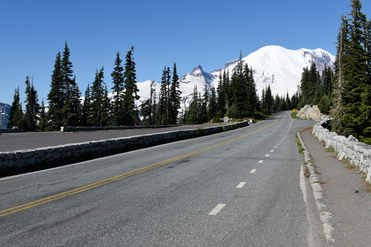
On a brilliant sunny day, we headed to Mount Rainier (our third visit in less than a week). Things were shutting down for the season, with snows already blanketing the high places like Sunrise, forcing the roads to close.

We had planned to drive a few miles up the road from the White River Campground, but even though the road was bare, the gate was barred. So we got to our destination the old-fashioned way:  we walked.

The views as we climbed were amazing, and so were the fall colors. We did our earthcache (the main reason we walked uphill for nearly two miles on perfectly good pavement), and as I turned to head downhill, my feet were perfectly placed on the double yellow lines.

I laughed out loud, and couldn't resist snapping a photograph. We couldn't be this close and not drive to the top of Chinook Pass, where the Mountain was stunning white above Tipsoo Lake.


7.12.2017

Reflections...


We took an early morning hike down to Sunrise Lake today, a steep downhill walk from the switchback viewpoint just downhill from Sunrise. This might just be the most stunning approach anywhere in Mount Rainier National Park. After the last switchback, it's a straight shot directly into the side of the mountain (or so it seems).


DW hiked this trail decades ago with friends, hiking past the Palisades and camping overnight in a meadow full of springs (and during the night, full of elk and wolves chasing the elk, a long and humourous story that I never tire of hearing). But today, we didn't go farther than the first lake.

I've been leery of this hike for years, because downhill all the way to the lake also means an uphill climb to get back out. But it really wasn't bad. There's just a bit of snow left on the trail, and on the hills that ring the lake. We had the trail to ourselves, found our earthcache, took a lot of photographs of the amazing reflections, and decided to walk clear around the lake before heading up.


From above, the lake is deep green. Down at the lake shore, it's a vivid blue that rivals the sky.

7.03.2017

Linger...


Today was our first day at Suntop. We left clouds and rain behind, and at a mile high, broke through the clouds to find sun and clear skies. A photographer walked up the trail to the lookout about an hour before color started showing in the sky. And it lingered on and on, well beyond last light. At 10:30, I was still walking around with my camera, looking for one last photograph.

This was the most magical sunset ever.


The setting sun lit up clouds in the Puget Sound lowlands like waves on the ocean


One of the lookout's original folding chairs from the 1930s


6.10.2017

The Mountain...

A friend recently wrote about spending a few days in a place she used to visit with her father, and how those old memories came rushing back. I thought it sounded wonderful... new sights and experiences to share with her husband, mixed in with the bittersweet memories of days past.

I know people who will never go to the same place twice. I don't understand that... seeing an old place with new eyes is one of the best experiences one can ever hope to have.


Sunrise on Mount Rainier, from Suntop Lookout

Going to "The Mountain" is like that for me. I can't begin to count the times I've been to this national park, let alone the memories that always come back to me as soon as I drive under the entrance timbers.

My earliest memory is from when I was a toddler. My parents were inside a nearby ranger station, leaving me and my sisters outside to watch the ranger's pet raccoon. I tried to feed it, and it bit me. Not hard, just a nip. The scar on my finger is long gone, but I never forgot.

Memories of my favorite mountain changed when I met DW. Our first date was a drive around Mt. Rainier in his red MGB sports car. We took a bucket of Kentucky Fried Chicken and sodas with us, and had a picnic in the meadows above Paradise Inn. Then we walked for a couple of hours, photographing the wildflowers. We were even temporary models for a photographer, who asked us to hold hands and be a frame for the meadows and the mountain in the background. It was the first time we held hands.

From then on, coming to our favorite landmark became a regular thing for us.  We can see the mountain from just about every place we go, and checking to see if it's "out" is a habit of 60+ years. We always pause to enjoy the view, and before we know it, we're dropping everything and driving south. It's a favorite place for a day's drive in our modern red roadster. It's my favorite place to photograph wildflowers.

Chinook Pass was reopened yesterday (we actually mark the calendar when the highway department expects to reopen the road). So of course, we had to drive around the mountain today. The road was wet with runoff, and as expected, Tipsoo Lake and the pass were buried in snow. There was fresh snow overnight, and the trees were beautiful


For an idea of how long and cold our winter was this year, check out this picture from June 26, 2015. Not 300 feet from the snow-covered bathroom building is where I took this wildflower photograph.


Our goal today was a hike to Boulder Cave, about twelve miles east of Chinook Pass, where the snow is gone and the wildflowers are just starting to bloom. It was drippy in the cave, and the ground was uneven and the footing was challenging, even with a headlamp, so the camera stayed in my pack. My cell phone snapped this shot inside this basalt cave.


It was a quick walk through the cave, followed by a not-so-quick stroll along the creek and through flower meadows with the camera, then we were on our way home via White Pass. All that snow is melting, filling rivers and reservoirs and waterfalls with runoff.

The rain held off until we got close to one of my favorite waterfalls, Clear Creek Falls. I had no protection for my camera but got out anyway to snap a few quick photos. All the times I've stopped here, I've never seen so much water thundering over the falls.


The heavy rain and mist in the air made it tough to get a good photograph today, but look at the difference between spring runoff and late fall. This one is from October 2005, when the larches were turning brilliant yellow and the waterfall was a trickle.


After a lot of geocaching along the highway and dinner in Packwood, we turned for home. Driving north on WA-123 through the eastern edge of the park, there were absolutely no cars on the road but ours.

We stopped at the entrance gate, with its huge cedar gate posts, so big I can't reach even halfway around them. I stood in the middle of the road for a photo, arms outstretched, embracing this mountainous place I love so much. It felt like the first time I'd ever been here, but at the same time, I knew I was adding another layer of experience that made all the other times that much more rich.

2.02.2017

Now you see it...

It was supposed to be socked in today, but when I looked at the eastern sky at 6:45 it looked clear over the Cascades. So I waved goodbye and grabbed my camera gear and lots of warm clothes, and headed south.

After days of rain and gloom and not even a glimpse of Mount Rainier, I wasn't going to miss this chance to photograph one of my favorite barns with a mountain backdrop.

As soon as I could pull over, I snapped a few quick photos of the mountain, with the morning colors just starting to show in the sky.


Then on down the road to the Dutch barn I found last week. When I first spotted the barn and the foothills behind it, I knew there was a big mountain hiding behind the clouds and could hardly wait to come back on a clear day.


And sure enough, there it was.


I love how in a climate like ours, even very big mountains can come and go with the clouds, completely changing the landscape.

1.23.2017

Mimic...


Twice in the past week I've visited this old red Dutch-style barn on the Enumclaw Plateau, and both times, Mount Rainier has been shrouded behind the clouds. On Friday the "clamshell" was visible on the horizon. It's what the locals call the craggy set of foothills that appear to cradle Mount Rainier as it rises out of the hills to its full 14,410-foot height. The shape of the barn is very similar to the shape of the mountain, and it's frustrating that the mountain is hiding behind the clouds. Next time the weather clears, another trip to the plateau will be in order, and I'll post more photos.

11.08.2016

Sunrise...

It wasn't exactly my kind of hike, but sometimes a closed road is the only trail to get you where you need to go.

    The double yellow was my trail today.

The road to Sunrise is gradually being closed down for the winter. You can't get up to the lodge any more, or even to the "big bend" where you can see three of the four major peaks in the Washington Cascades: Rainier, Adams, and Baker. From the closed gate by the White River campground, we only need to hike up about a mile to get to the earthcache we want to do before they close the road completely.

It's up, up, unrelentingly uphill. So I just put my head down and walked the yellow line, stopping occasionally to take a photo, and check out the view back toward Mt. Rainier. And sometimes I looked down at my feet, to the beautiful signs of autumn.

    A mushroom in the shape of a hard hat

   Wild strawberries turning crimson

The earthcache was all about the Osceola mudflow, which 5600 years ago took the top of Mt. Rainier and carried it down the mountains all the way to Puget Sound. This account gives me the shivers every time I read it:

"This was a catastrophic event, possibly triggered by a small eruption. About one cubic mile of hydrothermally altered rock collapsed as a giant landslide. It took the summit of the mountain, along with part of the northeast flank and the overlying glaciers, racing downwards toward Puget Sound, through the White and Green river valleys, reaching as far as Kent, 70 miles away. Moving an estimated 45 to 60 miles per hour, it covered 212 square miles with mud, rocks and trees, possibly as deep as 300 feet, and destroyed everything in its path."


The mudflow is visible today in various places, including the road cut on the way up to Sunrise. That's it behind me.


At the last corner, a huge cottonwood tree grew. High on the ridge, nowhere near water, it somehow took root and thrived. It was glorious in bright yellow, shining in the morning sun.


We headed back down the hill, glad to be going downhill. Just up WA-410 there's a place to pull off and see Mt. Rainier, standing at the head of the White River valley.moved on, heading toward Tipsoo Lake, we stopped to look at the mountain, with snow blowing off the top.


But by far the best view of my favorite mountain is from the highway just before the top of Chinook Pass, where the Pacific Crest Trail crosses over the road. In early summer, the meadows are full of wildflowers, and in the fall the bushes turn to gold and the lake swells from runoff. There's already been snow there, and soon the road will close until late spring.


9.30.2016

First light...


First light woke me this morning, and I dressed in all my layers and went outside with camera and tripod to photograph the waking day. DW lit the kerosene heater and started water for tea, then joined me on top of this knob of rock we've called home for the past few days. We watched for the sun to make it over the ridge of mountains to the east; sunrise so close to this peak we call The Mountain is a wonderful sight to see. Then we saw it: light glinting off the windows of the Fremont lookout, miles away, just this side of the three Burroughs peaks.

I'm going to miss this place.

9.26.2016

Top of the world...


For the next five days and four nights, we're going to be a mile high with a bird's-eye view of Mount Rainier. This historic fire lookout will be our home and our job. During the day, we'll show it off to visitors, and at night, it will be all ours.

The lookout stands on the the top of a knoll, with the road wrapping around it in a spiral. I stand on the top, and slowly turn in a circle. I am surrounded by mountains... the majestic Mount Rainier, the far-off Olympics, Mount Baker, Glacier Peak, Kelly Butte, the Alpine Lakes wilderness, the Stuarts, and a lot more I couldn't identify. A 360 degree panorama of the Cascades, even the top of the gondola at Crystal Mountain.


My sister, nieces, and great nieces came to visit us today, bringing lunch and smiles and excitement at being here to experience this awesome place with us.

We first came to Suntop in June of 2015 to find a geocache. I can't believe we're finally getting our turn to call this place home, even if just for a few days.

9.23.2016

Cold rain...

The weather has really taken a turn for the worse, but we're heading back to Mt. Rainier in spite of the weather.

East of Federation Forest, as we headed off to circumnavigate the national park, we looked both ways then hopped the guard rail and down into this forest of ancient trees. The patriarch has fallen, taking a fair number of big trees with it, to lie undisturbed between trail and river. You can climb up on the stump (which would hold my round dining room table and 6 chairs), but even more impressive is standing beside the tree.


Next stop, in even harder (and colder) rain, was the Box Canyon, which is in the park from Stevens Canyon entrance. We always stop here to walk the trail and look down at the Muddy Fork of the Cowlitz River. from this bridge, the surface of the river is about 130 feet below, and the canyon is less than 18 feet wide.


As you walk the loop, the huge rock to the right is scoured with deep glacial scratches. We crossed the bridge and decided to keep on walking the loop, even though that meant scrambling over a couple of downed trees. Thoroughly wet by this time, we ran back to the Pilot.


The last stop was at what is probably my favorite waterfall, Christine Falls. It's another place in the park where we always stop, and rarely do we get to see it without fifty people in the way of my photo. The weather worked to our advantage today. Christine Falls is a two-drop falls and is very pretty, but what makes it a beautiful view is the frame made by the stone bridge that crosses the river. I know the view so well, but I never get tired of it.


Wet, but happy with our day, we headed for Buckley and a burger and beer at The Firehouse. Relaxing in this packed bar and grill was the perfect way to end a long day.

7.20.2016

Rail trail with a view...


There's a mountain in there... really. But today it never showed its face. So as we walked the railroad grade south to Enumclaw, I had to be content with pastures and woods, hedges and barns, and the occasional cow (or herd of cows). It was a perfect day for a hike, and a couple of dozen geocaches. And a burger and a beer at The Mint afterwards.

6.15.2016

At the top of the world...


A bit over a year ago, we discovered Sun Top lookout while exploring the logging roads north of Mt. Rainier, and met the two women who were volunteering there for a few days. They gave us a tour of the lookout and explained how to watch for fires. As soon as we got home, I called and got our names on the volunteer list.

Tonight was the orientation meeting to learn about volunteering at one of two lookouts, then we waited patiently for our numbers to be drawn. And by the end, we were among the lucky ones.

On top of a high knoll, the lookout has a 360 degree view of the horizon, and a drop-dead gorgeous view of Mt. Rainier. And it will be all ours for four days.

10.27.2015

Caching Rainier...


A road trip with our Aussie family today, to do some geocaching on the flanks of Mt. Rainier. We started with a barbecue lunch at Mud Mountain Dam, where the kids blew off steam in the playground. We drove up the Mowich Lake road, all the way to the park boundary. This has become one of my favorite views of the mountain. From here it isn't the rounded peak that you see from anywhere around Puget Sound. It's rough and craggy and icy. You can clearly see massive cliffs, and snowfields, and glaciers. It's impressive.

George brought a geocoin all the way from Tasmania, and wanted to drop it in a cache in sight of Mt. Rainier. This one turned out to be perfect.