5.22.2010

Neighborhood bakery

Somewhere on the south hill of Spokane, there's a fabulous neighborhood bakery. Kathy took us there for breakfast this morning, and I love that it's right there on a residential street. People walk to it or ride their bikes... plenty of racks to leave bikes right outside the door.

If we lived anywhere near this charming bakery, we'd be regulars. It has a wonderful open, friendly, airy feel. I loved the storefront—tall windows, brick walls, a perfect place to get coffee or herb tea, then browse the pastry cabinets and choose from the dozens of varieties, from eclairs to muffins, sweet rolls and all kinds of flaky pastries. It's the perfect place to enjoy your coffee with a bit to eat, and read a while.


5.15.2010

Dead horses

Today was a drive from the resort on the Colorado River, south toward Canyonlands. We're headed to Dead Horse State Park, and it was a great sports car drive—19 cars in all, a good group of sporty drivers and it was fun to drive this road with them. We stopped at the visitors center first, to get oriented. I bought a floppy hat with a wide brim, to keep the sun off my neck. After all the cold weather and snow in several states on this trip, we're finally getting sunny weather, and I'm starting to get a sunburn.


Then we drove the rest of the way out to the point, and with some creative parking, managed to get everyone in the small lot. There are gorgeous views from here, probably the best views of the Colorado River side of Canyonlands, because you can actually see the river.


The park is on a narrow plateau, which was used as a natural corral by cowboys in the 19th century. The plateau is 2000 feet above the river, and has a narrow neck that was easily fenced to create a natural corral. Cowboys would drive herds of wild horses onto the mesa, then fence off the opening.

How the last herd of horses got left behind, where they eventually died of thirst, is not clear. It's best to think that it was accidental, that it was a "I thought you were supposed to do that" sort of mixup. It could be that someone was told to ride out and take the fence down, and they forgot. Or it was just not considered worth the time to make the long ride. We'll never know. But I don't for a second buy the story that the fence was taken down, but the horses inexplicably wouldn't leave the plateau. That's a story concocted by someone who's never lived with horses. Horses are much smarter than that.

The other times we've come to Moab, I resisted coming out here because of the legend. As a lifetime horse lover, the thought of horses abandoned here was so painful, and I just didn't want to see where it happened. But I'm glad we came. It's a gorgeous spot with amazing views, and I could have stayed here for hours just watching the clouds blow through, and the ever-changing views.

5.14.2010

Petroglyphs

This morning we went on a sports car drive and hike, and on the way back to Moab, we stopped to see this group of petroglyphs. We were surprised at where they were; we'd driven right past them earlier and didn't even see them. It's because a road engineering and cleanup project years ago had an unexpected effect: removing a steep talus slope put the figures about 30 feet off the ground, out of reach. Aren't these great figures?


We must have disturbed a small bat at one point; he flew right in front of my face and landed on the rock. With my long lens I was able to get a pretty good look at him.


Arch with a view

This afternoon we took a solo drive through Canyonlands National Park, to get the earthcaches and virtual caches there. We stopped at the visitor's center to get pins and hiking stick medallions, then drove out to the end of the road and worked our way back. It's warm today, thank goodness! Shorts and short sleeves felt good after all the cold and snow we've had so far.

From the last viewpoint you can clearly see the White Rim, the actual rim of the canyon (it's white because of the exposed layer of rock at the edge). From the viewpoint it's 2000 feet down to this level, and another 2000 feet down to the river. Awesome.

We really liked the walk out to this arch, and the views out over the canyons. The kids took turns walking across it, and I asked these three guys to pose for me. I think it made a great photo. And in case you were wondering... the arch was at the top of the cliff, but it was out over the sheer drop to the bottom of the canyon. If you fell, you'd fall a very long way.


5.13.2010

Snowstorm #3

We're climbing now, heading toward a 10,000 ft. pass, the highest point between us and Moab. It's not snowing yet, but it's cold and windy and you can smell the snow in the air. Eventually we reached the sweet spot—where the elevation of the road finally climbed up into the snow zone. This time (our 3rd snowstorm of the trip) the snow lasted almost 2 hours on a road that climbed twice to almost 10,000 feet. We changed the GPS view to show the elevation plot, and we kept an eye on it as it rose.

All along the road were gorgeous stands of aspen trees, not the stunted trees you often see at high elevations, but perfect huge trees. If it had been warmer (and there hadn't been a white-out), I would have been out with the camera. For eight years I've been looking for just this kind of aspen forest, so I can take a wide-angle photo of the white trunks. I'll just have to come back. We stopped once at a big overlook, where the sun was breaking through clouds, giving us a wide panorama of mountains the in the background and canyons in the foreground. But the snow kept blowing, and we had to keep going.

Snow like this in May is probably not unheard of around here. But an MX-5 Miata doesn't play well in a snowstorm, and it doesn't wear tire chains. So we were relieved to finally drop below the snow zone. We stopped for a photo of the snow plow schedule, just as a group of motorcycles headed up the road toward the pass. They were in for a cold ride.

Searching for aspens

A few years ago we went mountain biking in Moab with a group of friends. We rented a house in town big enough for all of us to have separate bedrooms. Our room had a beautiful wide-angle photograph of aspen trunks. I've been looking for my own grove of aspens ever since.

Today, as we climbed the series of passes through the mountains between Bryce Canyon and Moab, we saw so many beautiful groves of aspen trees. But there was a blizzard raging outside the car, and the views were as much in our imagination as reality, so once again, I couldn't capture the aspen photos I wanted. Very disappointed.

This is a photo that Dave took in 2004, on our first trip to southern Utah. He cropped it to a similar size, but we never found a grove of consistent trees to make the picture we really wanted.

5.12.2010

Pet Grouse

Finally, we're in Bryce Canyon National Park. The snowstorm that hit us in Zion this morning also made its mark here, and the red rocks and hoodoos were spectacular with a dusting of snow. We drove the road through the park, all the way to the end, then worked our way back. Such spectacular views from this mesa, I couldn't stop snapping photos and playing with the polarizer to get the best, brilliant blue skies. It was bitterly cold, though. Even though the sun was out, the wind was killer.

We bundled up into everything we had—for me that was my hoodie, black fleece jacket, fleece vest, baseball cap over the hood, gloves. And I was still so cold I couldn't stay on the canyon rim for more than a few minutes. I actually got brain freeze, like you get with very cold ice cream. That was a first.

At the overlook to the natural bridge (which is really an arch), I walked over to the edge to take a photo and enjoy the view, and turned around to see a ruffled grouse walking toward Dave. When he crouched down to take a picture, I got a good shot of him and the bird. Funny little thing… when Dave turned to walk toward me, the bird walked right alongside. He called it his pet grouse, and that he was taking it for a walk. The others around us were very amused.

5.11.2010

Zion in the snow


Today was an amazing day in Zion National Park, during a freak snowstorm. The weather forecast was for low 60's today, imagine everyone's surprise when they got a dump of snow instead! We took our time driving through the park, and when the sky started to clear up, we scrapped plans to bolt for Moab, and instead we stayed in the park to photograph it in the snow.

This is one experience I will never forget... especially since we were in our Mazda MX-5. We were headed to Moab for a regional Miata event, and in our nine-state road trip through the West, we ran into snowstorms in five of them!


5.10.2010

Grand Canyon is closed

Today we're heading for the North Rim. Once out of the hills and river valley that led south out of St. George, out into the open plains north of the canyon, we could see red rock mesas all around us. Beautiful.

But unfortunately, the North Rim isn't open for the season yet (it opens next weekend). Bummer. We tried driving up the road anyway, and at the barricade was the entrance to the campground, so we drove that way and found a historic ranger station that was really cool. This is where they stable the horses and mules for trail rides; they were hauling in hay and getting ready for the season.

The road was interesting, so we kept on going. Where it came back to the main highway was an old fire lookout station. There was a geocache there, so we parked the MX-5 and took a walk to find the cache. As we walked back up the hill, we had a great view of the contrast between the wee car and the very tall tower.

5.09.2010

Winnamucca to St. George

My turn to drive this morning, east on I-80 and 75 mph in a windstorm! Yahoo! It took miles to get past a trucker who kept driving down the middle of both lanes. Sleepy? The scenery across Northern Nevada is breathtaking.

We stopped for gas in Carlin, then took Hwy 278 south to US-50 and kept on heading east. One gorgeous valley after another, separated by ridges and snow-topped mountains. Up and over a pass, drop down twisty roads to an open range with creek or river, farmstead, then up the next ridge. We stopped often to pick up caches. The sagebrush is bright green; no lack of water at this time of year.

Ground squirrels abound here, on all of the roads, along the roads, in the fields. Honk and they scatter—we learned quickly that this is better than swerving around the little moving pylons! Old telegraph poles pinpoint a narrow gauge railroad line, long gone.

We stopped at Pancake Pass for a geocache. Found a pile of narrow-gauge railroad spikes and other hardware. Sorted through and picked up 4-5 to bring home. Still lots of snow at the higher ridges; the pass is 8000+ feet, cold at any time of the year.

I drove from here to St. George, and the wind never let up. Added to the awful Utah highways, with tar-filled bone jarring cracks, and it was a wrist-jarring 70 mph drive, fighting to keep the MX-5 on the road. I was so glad to turn off onto Hwy 18 and head NE through the last mountain range before we reach Utah. There's money here, you can tell by the perfect surface of this highway. Great roads with grassy shoulders, big cattle and horse ranches.

Just before St. George, we passed a spectacular red rock canyon, and didn't have time to explore. Bummer. There are a bunch of earth caches in there. But it was was getting late, and we still needed to find a hotel and something for dinner. Finally settled on a hotel, a small place that was $40 with taxes, but very clean and nice. Plus it was in town, so we could just walk next door for a restaurant. The Mexican restaurant was closed, but the Thai place was booming, so we ended up there. Great food, good atmosphere, even a sushi bar. Dave had curry, I had something with chicken and veggies. We saved our leftovers for tomorrow's breakfast.

5.08.2010

Back roads | Eastern Oregon

It's cold this morning. We're climbing out of LaGrande, heading for Baker City. We were at snow level in about 5 minutes! The highway climbs through the mountains to a flat plain of brilliant green grass, with dozens of Black Angus cattle and tiny little calves running about. Off to the right, the spectacular Anthony Lakes Wilderness area, bright in the early morning sun.


We stopped for gas in Baker City, and as soon as we got off the freeway, remembered this historic town from our last Moab trip. It has an 1880's courthouse, tree-lined streets full of old homes, manicured yards, wide streets. Great views of the mountains; wonder how cold it gets in the winter (and how much snow)? From here we head south on Hwy 7—the Elkhorn Scenic Highway. Gorgeous and remote, it's a great road for a sports car.

When we spotted this railroad museum, we had to stop even though they don't open until Memorial weekend. Spent an hour+ there, wandering through rolling stock and buildings, taking pictures, and doing some bird watching. It's still cold, though. All through this valley are the gravel piles of dredging; they've been here a long time judging by the size of the trees growing on them. Mining just tore up this gorgeous valley, leaving a wasteland of gravel pits and hills, with the river running through them.

Climbed over another mountain range to the town of John Day (we've been here before, but not by this route), then Canyon City. Amazing sports car road along the river, all the way to the town of Seneca.

There were endless photo opportunities, including a beaver dam, an oxbow lake wannabe, and the rusty-orange moose brush everywhere. Are there moose in NE Oregon? The road continued to climb and we started seeing Snow Zone signs; not comforting when driving in a Mazda MX-5, especially when we ran into snow yesterday when crossing into Oregon.

This will be the longest driving day of the trip, all the way to Winnamucca, Nevada. We passed long ranges of hills, endless cattle ranches, climbing up, then dropping down into long river valleys. Neither of us have ever driven through this part of Eastern Oregon. It's vast.

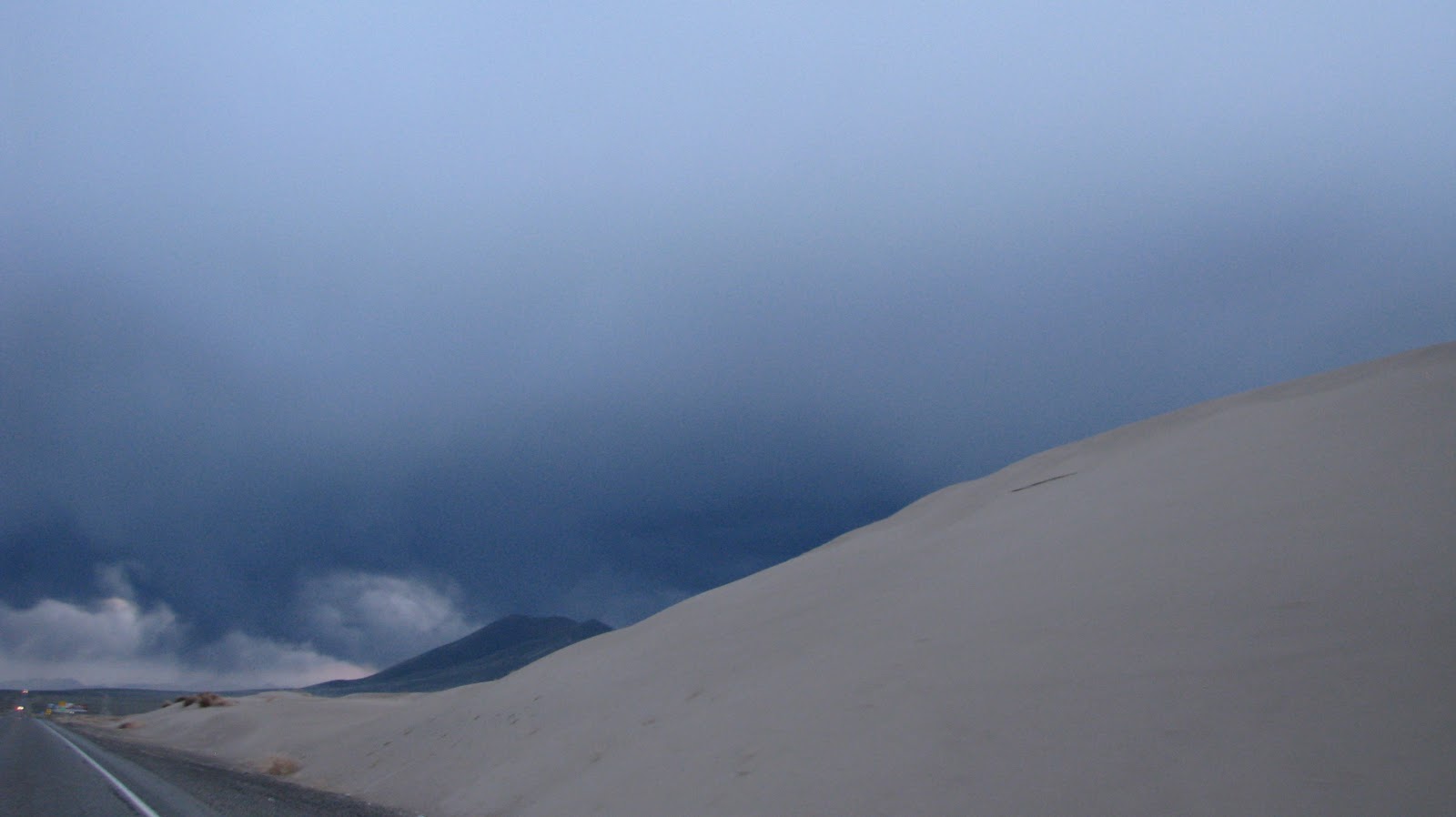
From 20 miles away we could see the huge thunderstorm hanging over town; kept expecting the skies to open and the rains to pour down. It was raining, but the rain never reached the ground. The huge sand dunes that stretched away on both sides of the highway were a magnet for ATVs of all sorts, even on this cold, windy day.


We spent the night in Winnamucca; after we chose a hotel, we found dinner at the Griddle, a diner on the main road with 1940s Nile Green booths and counter stools, lots of stained glass and Tiffany pendant fixtures, and amazingly good food. I had a turkey & roasted red pepper sandwich, with chipotle sauce. Yumm.


There's lots of Basque heritage here; unfortunately, we missed out on the traditional food because we didn't read about the town until breakfast time.

5.05.2010

I'm so behind...

Between home and work and my hubby and a niece's engagement party and family and friends... (deep breath, relax, breathe) and work and getting ready for vacation and pruning blackberries before they take over the farm and pulling weeds and more work and teeth cleaning and the eye doctor telling me I may need bifocals soon... (breathe, just breathe) and windstorms and keeping up with my geocaching streak and (is this a run-on sentence, or just creative writing? I'm sure someone on the blog police squad will tell me) and learning a new GPS and charging batteries for all the electronics that use AAs and more work and catching up on e-mail...

I've neglected my blog. I write every day, and promise to catch up soon.